
Gullfoss Waterfall: Viewing and Visit Planning
Plan Gullfoss around the upper and lower views, facilities and weather limits. Read the official source, then choose the route that suits your day.
Choose the waterfall visit
A broad marked view can suit a short visit. The lower approach and connecting route need their own access checks. The Brattholt trail is a separate longer outing.
Viewing tasks with their limits
Choice: Upper marked views
- Useful for
- Falls and canyon in one wider setting
- Check first
- Current path conditions and nearby service hours
Choice: Lower approach
- Useful for
- A different, closer angle when open
- Check first
- The specific path notice and the return
Choice: Brattholt trail
- Useful for
- A longer marked walk
- Check first
- Route start, conditions and sufficient time
Official Gullfoss reserve and visitor information · · © thingvellirnationalpark.com.
Gullfoss waterfall is a separate stop from Þingvellir, with its own paths, viewing areas and weather limits. The river Hvítá drops in two stages. It then runs through a canyon. You can plan a broad view, a closer walk when open, or a longer marked route. Those choices need different amounts of effort and spare time.
Start with the marked viewing route that suits your group and the day's conditions. The upper area has nearby visitor services; the lower approach is a different walking choice. Do not assume every path is open because the site can be visited. Check signs, the weather and current notices, then keep enough time to return to transport. A waterfall view does not require crossing a barrier.
Last fact checked: 14 October 2026. The official site care pages are the main sources for the reserve. Private service hours and any current payment rules need their own checks.
Where Gullfoss waterfall fits on the day
Gullfoss is on the river Hvítá in south Iceland. The official reserve page names the waterfall and the canyon below it as parts of the protected place. That is a different setting from Þingvellir's assembly grounds or Haukadalur's hot springs.
For a park-first day, give Þingvellir time for history and the visible rift. The park overview helps you choose that walk. Gullfoss then adds a river and canyon view. The places tell different stories. You need not race through the park to reach another photo point.
A Golden Circle excursion commonly includes both, along with the Geysir area. Read the exact itinerary before assuming how the day is split. The tour's total length is shared among stops and driving. It does not tell you how long you have at Gullfoss or which paths the guide will use.
Our Thingvellir tours comparison names source-backed formats and their drawbacks. Use it to decide whether transport is the main task you want an operator to handle. For a self-drive visit, choose the route around current road conditions and your next stop, not a sequence of best-case drive times.
Gullfoss waterfall viewing options at a glance
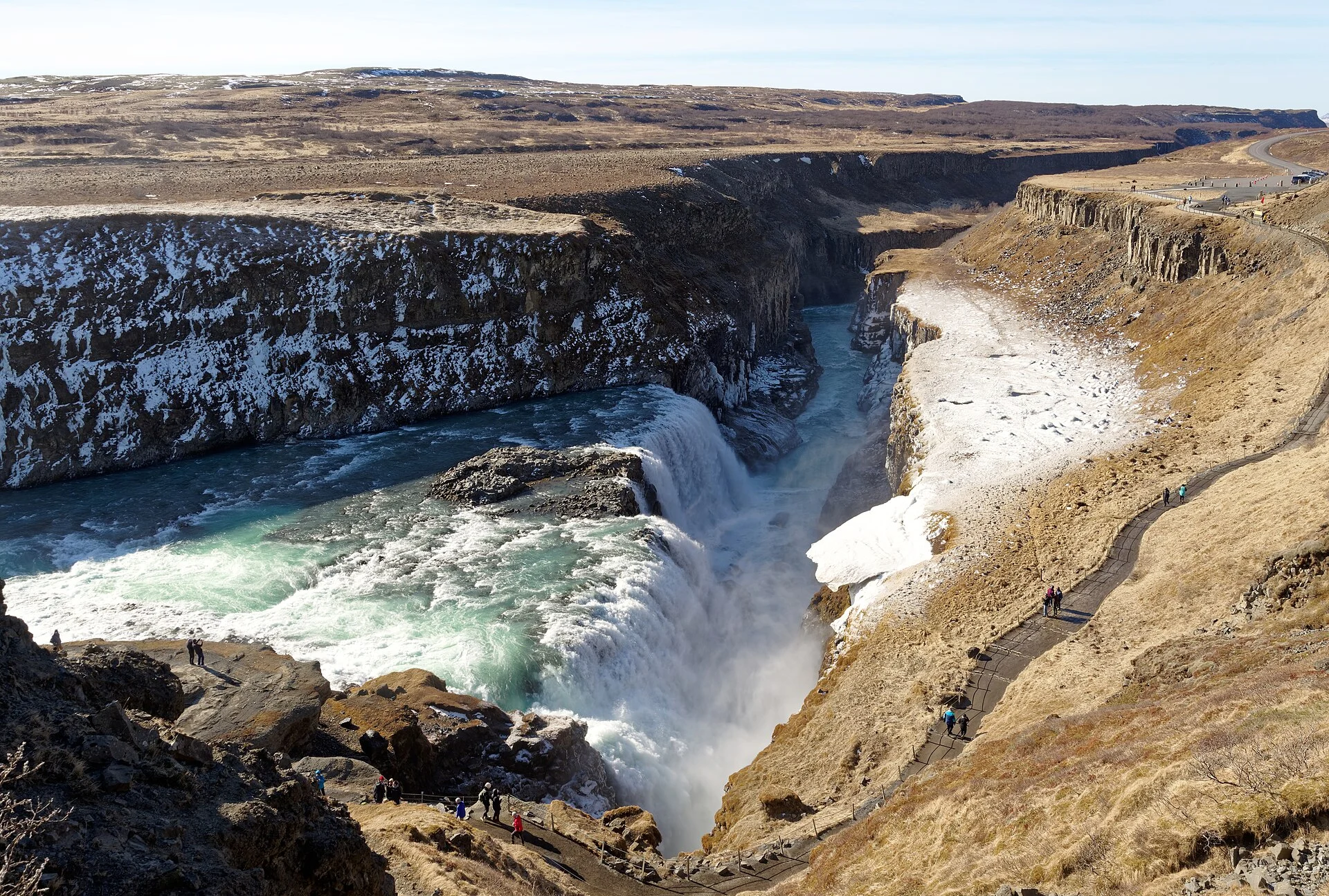
The upper and lower viewing areas provide different ways to read the falls. A broad view shows the drops and canyon together. A closer approach, when open, changes the angle and brings more spray. Neither is automatically the right choice for every visitor.
Use the lookout guide for the route decision. It separates the viewing areas, connecting steps and the path toward the waterfall. Check whether each part is open before treating them as a single circuit.
- A broad view: start with an open marked viewpoint that shows the falls in the canyon. It can meet the needs of a shorter visit.
- A closer view: use the established lower approach only when it is open and suits your walking needs.
- Both areas: allow time for the connection and return. Do not assume that a path between them removes the effort of steps or a slope.
- A longer walk: check the marked route toward Brattholt as a separate outing, rather than attach it to a quick photo stop.
An attractive image from another season is not an access guide. Snow can hide ground edges, and spray can make a route wet even when the wider day is dry. Choose the view from the conditions you find, rather than the exact frame you hoped to copy.
Read the two drops and the canyon
The official geology account describes two falls and layers of rock and sediment. Water does not wear every layer at the same pace. The river washes loose gravel out of rock layers. The source explains how this helps the falls and canyon cut back through the ground.
You can follow the broad idea without identifying each layer by sight. Look for the river above the first drop, its next descent and the canyon beyond. Then use the official explanation for the process. A photo shows the visible form, but it cannot measure the full speed or history of erosion.
The agency discusses more than one explanation for the canyon's formation. One involves a large glacial outburst at the end of the ice age. Another involves the river cutting its course over time. The page regards the second account as more plausible. It does not prove one dramatic event for the whole canyon.
That distinction matters when a tour account reduces the site to a single neat story. Keep the source's level of certainty. You can enjoy the view while saying that the official account weighs alternative explanations. There is no need to invent one exact flood date or a fully settled origin.
The river's flow also changes. An average stated in a broad geology page is not a live reading for your visit. Nor does a strong-looking flow tell you that every path is open. Water conditions and visitor access are different facts, with different sources.
Spray, light and the view you will actually get
Spray is part of the waterfall setting. It affects visibility and the surfaces near a view. Wind may carry it toward you or away from you. If the position is uncomfortable, use another allowed view or shorten the stop. Do not move outside the path to escape a cloud of spray.
A rainbow needs the right light and angle. It is not an inclusion in the visit. A sunny picture can show what occurred at one moment, but cannot promise the same view on your date. Plan the waterfall itself as the reason to stop, rather than an exact photographic effect.
Keep equipment ready without losing track of the route. A camera bag should not block steps or a viewpoint entrance. If you stop for a longer recording, let other visitors pass. Avoid balancing a device beyond a railing or climbing a barrier to remove it from the frame.
You can also put the camera away for part of the stop. Watch the river and its drops as a sequence. That can show the scale better than one wide frame. Read the signs and keep the wider canyon in view where the allowed route permits it.
Parking and visitor services
The agency's history and services account places a restaurant, coffee shop and shops by the upper parking area. Check the exact business if you need a meal or facilities before or after the walk. The outdoor visit and a private building's opening hours are separate.
Use our Gullfoss parking guide for the distinction between entry and parking. Other services have their own terms. A car-park label does not establish the current fee, payment method or consent for every vehicle. Read the signs for the lot you actually use.
Gullfosskaffi's own FAQ says that visiting the waterfall is free. That supports a statement about sightseeing entry. It is not a full tariff for every separate service, and it does not make a closed path open. Check any current parking rule on arrival rather than infer it from a broad free-entry statement.
What's New in 2026: a proposed future access system
The government consultation published in September 2026 concerns a proposed access-charge system for Gullfoss, Geysir and Þingvellir. Its planned start is in 2027. The record was still being processed when checked in October. A planned date is not a current payment instruction.
For this visit, keep the proposal separate from the site's present rules. It does not change a closed path into an open one or replace a parking notice. For a future trip, recheck the final official position before setting a budget.
Our parking guide separates admission from parking. It covers the proposed system too. An older free-entry statement and a future policy answer different questions. Do not merge them into one cost claim.
Seasonal limits: a site is not one open path
The waterfall may be visible while one approach is closed. A limit near the falls may leave upper views open. An open upper view does not prove the lower path is open. Read the notice for the exact route it concerns.
Visit South Iceland's Gullfoss page points visitors to SafeTravel for conditions. Use current details close to the visit. Old winter notices show why a route closed in the past. They are not live reports for today.
The agency has published past notices about heavy snow and temporary closures of the connection between viewing areas. That is useful proof that winter can affect single routes. It does not mean all routes close each winter. Nor does it mean the same closure is in force now.
In cold weather, keep the return in mind. A descent may look easy before you walk back up. Wet ground can become harder after the temperature falls. Choose the route for the full out-and-back task. Turn around while you still have time and energy to return without rushing.
Choosing a route for your group
Make the walking decision before everyone leaves the car. Ask whether the group wants a short broad view or a closer approach if it is open. Note any need to avoid steps, slopes or a long time standing outside. Those needs should decide the route, rather than the most dramatic photo in a search result.
If you need an accessible approach, ask the site about the current parking and path terms. General descriptions of an upper or lower area are not a full accessibility assessment. Surfaces, barriers and winter conditions can affect the route on the day. Use an exact question about the task you need to complete.
A pushchair and a wheelchair may have different needs. “Easy walk” is not enough detail for either one. Check the connection you intend to use and the return. A shorter allowed view can still provide a good stop without committing to every path.
For a guided trip, tell the operator about those needs before booking. Confirm whether the group walks together, has free time or uses a fixed route. An itinerary listing Gullfoss does not establish that its exact approach will suit each member of the group.
The marked route toward Brattholt
The agency's history page also describes a marked trail between Gullfoss and Brattholt. It gives an approximate distance of three kilometres one way and six kilometres for a return. These are the source's route figures, checked October 2026, not a measured duration for your walk.
Treat this as a separate walking plan. Check the start and return before setting out. Read the current conditions too. Do not use a broad waterfall visit estimate for a longer trail. Leave enough daylight and spare time, and use a current map rather than the place names alone.
The official description calls the route fairly easy, but that is a broad account. Your own fitness, footwear and the weather still matter. Ask about the path if something is unclear. Do not turn that adjective into a guarantee for a child, a mobility need or a winter outing.
If the waterfall is already a stop within a full touring day, the longer trail may not fit. There is no need to add it to make the visit complete. A shorter marked viewpoint route has its own purpose. Choose one task you can do comfortably rather than a list whose return you have not planned.
Protection and the history behind the site
Gullfoss and the canyon below it were protected in 1979, according to the official reserve account. Protection also covers the plants and other natural features. Stay on the marked routes so an additional informal path does not damage the ground beside them.
The official history page tells the story of Sigríður Tómasdóttir in Brattholt and efforts to protect the waterfall from power development. It also describes later ownership and land donations. These form part of the site care history, beyond the simple fact that the falls still run freely.
Use the site's memorial and signs to read that history. Do not invent a dramatic retelling or imply that a legend establishes each step in the legal case. The agency's account provides dates and context for the people involved. A visitor overview can direct you to that record without turning it into imagined dialogue.
The source mentions remains of former settlement around the canyon, including old roads and stone structures. They are not places to move stones or make a picnic surface. If you see a low feature, view it from the route. An old-looking structure still needs signs before you assign it an age or purpose.
Site rules and careful photos
The reserve's published rules prohibit off-road driving and damage to plants or wildlife, as well as natural features. Use marked vehicle access and keep the walking route clear. A quiet period at the site does not make the rules optional.
The same page says drone use needs consent. Do not launch one merely because the view is clear or another visitor is flying. A consumer aviation rule and a protected-area consent are separate checks. This page does not give a single flight consent.
Keep photos honest about their date and location. An image showing summer access cannot tell a winter visitor which path is open. A picture taken from a marked viewing area should not be labelled as consent to go beyond it. Give the feature name and the actual context you can establish.
The real photo on this page shows Gullfoss, with its source and licence below. It does not document current flow or walking conditions. Those still need checking for your visit. The image helps you recognise the place while the official sources provide the rules.
Continue a park-first day
After Gullfoss, return to the route that fits your remaining time. If Haukadalur is also planned, read the Strokkur guide and Geysir area account for their distinct features. Do not assume a spring's viewing time and a waterfall route require the same preparation.
An overnight base can make the day less rushed. Use the Thingvellir hotel comparison to check location and room type against both the park and the following morning. A rural hotel may suit the route, but check meals and arrival before relying on it after a long day.
Keep one fixed plan in view at a time. A booked activity, hotel check-in or tour return has its own deadline. A suggested sightseeing duration is flexible. Shorten an optional walk rather than let it push the rest of the day into a rush.
Frequently asked questions
Must you use both viewing areas?
No. Choose an open marked view that suits the group and the day's conditions. A broad view can meet the needs of a shorter stop. The closer route is a separate choice, with its own effort and possible limits. Plan the return before adding it, rather than assume every path belongs to one easy circuit.
Does free entry mean all paths are open?
No. Gullfosskaffi's FAQ describes free sightseeing entry, while access still depends on conditions and local limits. A lower path can be closed without removing every wider view. Check the notice for the exact route, then follow the signs on arrival. A payment statement is not proof of safe or free walking.
Is the proposed access charge already in force?
The linked government record is a draft consultation for a proposed future system, with a planned start in 2027. It is not a payment rule for this October visit. Check the latest official position before a future trip. Keep a proposal, a passed rule and an actual site's current payment process distinct.
Can you fly a drone over the falls?
The reserve's published rules require consent for drone use. Do not treat the lack of a crowd or another person's flight as that consent. Check both the protected-area rule and applicable aviation rules before planning a flight. This visitor guide gives no single consent and does not promise that a permit will be granted.
Verdict on Gullfoss waterfall
Give Gullfoss waterfall a clear place in your day: a marked view, an optional closer route or a longer walk checked separately. Read the two drops in their canyon setting, keep weather limits in view and leave time for the return. Then fit the stop around the park visit, transport and overnight plan you actually want.
