
Thingvellir National Park Tectonic Plates: What You Can See
See what Almannagjá and Silfra show about rifting, read a clear process diagram, and avoid common claims about the edges of continents.
The Thingvellir National Park tectonic plates story is visible in faults, cracks and a valley floor that has sunk as the crust pulls apart. Almannagjá is one of the clearest places to see those effects on land. The mistake is to treat its facing walls as the two distinct continents, with one narrow gap doing all the work.
Þingvellir belongs to a broad active rift zone. Rock stretches and breaks. It can drop along faults, so you can see cliffs and lower ground. Almannagjá and Silfra are parts of that system, not a complete plate boundary in miniature. Read the reference below as a process diagram, then use the signed paths to look at real features. It is not a map for leaving the path.
Last fact checked: 14 October 2026. Sources are the park's geology pages, linked beside the explanations.
Thingvellir National Park tectonic plates in plain English
A tectonic plate is a large piece of the Earth's outer shell. Iceland lies across the Mid-Atlantic Ridge, where that shell pulls apart. The process makes new crust and creates faults. A fault is a break along which rock has moved. A fissure is a crack, which may be open or filled with water.
The park's tectonic movements account places Þingvellir within this wider system. It sets out sinking ground between faults as well as spreading. You need both ideas to read the view. The low valley floor is as much part of the story as the cliff beside your path.
“The plates move apart” is a useful start, but it does not describe every local feature. Several faults share the strain. The ground between them can move in blocks. A surface crack is not a labelled border that separates whole continents on either side of your boots.
This distinction also explains why a guide may talk about North America and Eurasia while the park's detailed Silfra page names Hreppafleki. Hreppafleki is a smaller crustal block, described by the park as the Hreppar microplate. A broad account and a local one can use different scales. Use the local source when making a claim about one named fissure.
Read the rift reference before the view
The diagram below is an original schematic based on the park's account. It shows the idea of stretching crust and sinking ground along faults. It does not locate a footpath, measure a cliff or mark the exact outlines of plates.
The labels link the sketch to Almannagjá, Silfra and Lake Þingvallavatn. The arrows show the broad spread of the crust. They do not place each wall on the edge of a continent.

On a visit, look first for the high wall and the lower plain. Then look for other cracks from the path. That order keeps the larger setting in view. If you begin with one dramatic close-up, it is easy to miss the scale of the valley around it.
The textual equivalent is simple: tension pulls the crust apart; faults allow blocks of rock to move; some ground drops between faults. Lava and water then interact with those breaks. The present park contains the results of many events, rather than one single split frozen in place.
What Almannagjá shows on the walking route
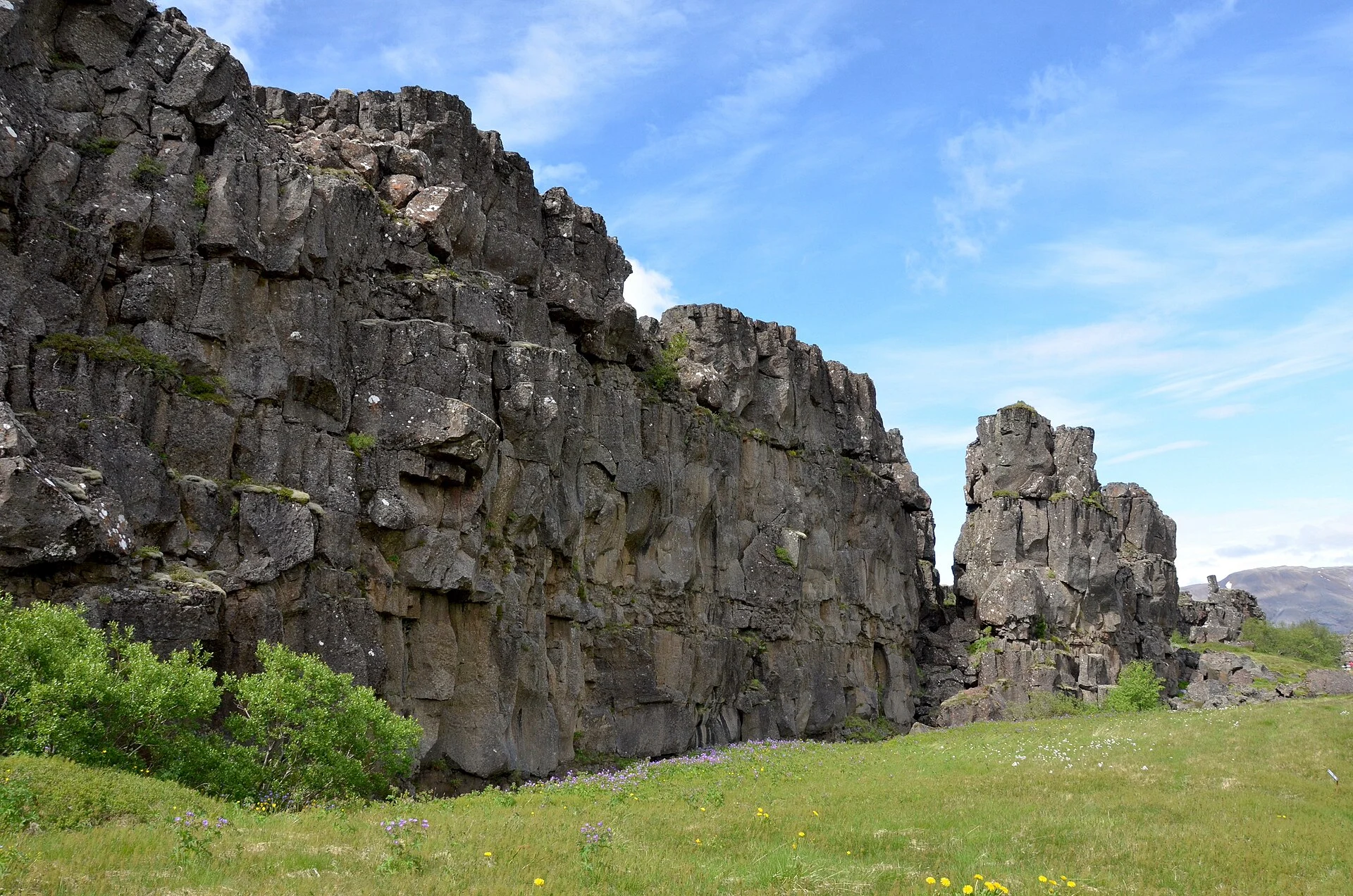
Almannagjá gives you a visible rock wall and a route through the fault area. The feature helps make the abstract idea of rifting concrete. You can compare the height of the wall with the lower ground nearby, while keeping to the marked visitor path.
Do not read the wall as a cross-section through the whole Earth. What you see is surface rock. The process below it is much larger than the exposure in front of you. Nor can the colour of one rock tell you which continent it “belongs” to without geological context.
Use the park's signs to connect the feature to the wider view. Avoid turning a walking route into an informal climbing route. Loose rock, hidden drops and water-filled cracks are poor places to test an account found online. A photo from the path can show the same fault without using it as a climbing surface.
Weather affects the way you read the site too. Snow can hide the edges of cracks and the lower ground. Mist can remove the long view while leaving nearby walls visible. In either case, keep the account distinct from a guess based on one angle. If visibility is poor, the account at the visitor centre may be more useful than trying to force a wide photo.
What Silfra does and does not prove
Silfra is a water-filled fissure at the northern end of Þingvallavatn. It is famous for underwater visits, but the park's Silfra page warns against two common claims. It is not the whole gap between plates, and it was not simply created in the often-quoted year 1789.
The source places Silfra within a wider zone and sets out evidence that it existed before that date. It also distinguishes the fissure from the much broader space between crustal boundaries. A narrow channel that is easy to photo can make that distinction hard to grasp at first.
Clear water does not settle the geological question. Water moves through lava before reaching the lake and fissures. That helps explain the view underwater, but clarity is a water story. It is not proof that the two sides are the complete edges of the North American and Eurasian plates.
Separate the science from the activity choice. A snorkelling trip can give a close look at a fissure. It does not replace a wider rift account, and it is not required to see visible geology in the park. The land route and a water booking serve different visitors.
What the landscape cannot tell you by itself
A still photo cannot show a spreading rate. A gap's width does not tell you when it first formed without further evidence. The same applies to the shape of a cliff: erosion and past movement, as well as the rock's original layers all affect what remains.
Avoid treating a yearly plate-motion estimate as a promise that the crack beside you widens by exactly that amount each year. The park explains that stress can build and then be released in events. A long-term regional rate and local movement are different measures.
You also cannot infer safe access from a picture. A person standing near water or a rock edge may be in an area that is closed, restricted or unsuitable for you. Use signs and latest park advice to plan your route. Older photos can document a feature while saying nothing about today's access.
The lake guide explains how the water fits this setting. For the human history, read the Althing account. The same valley has both stories, but one does not prove the other.
Where to see the geology during a park visit
Start with the signed old meeting area route and the view around Almannagjá. Match your arrival to the route you intend to walk. The park's parking page distinguishes Hakið, Efri-Vellir and Valhöll. Check the latest map rather than assuming all lots have the same approach.
Add the church and Drekkingarhylur if you want to connect geology with the meeting area's history. Keep these visits on the signed route. Use them to learn about the place. Do not seek a private shortcut across the cracks.
If you want a guide or transport, use the Thingvellir tours comparison. Choose by time at the park and the guide's stated focus. An overnight base is a different decision; compare hotels near the park by road access and your next stop.
For the written names on signs, use the Thingvellir pronunciation guide. Its English practice aid is labelled as an approximation, with a credited recording of the Icelandic name. If your next stop is a hot spring, the Strokkur guide explains that distinct part of Iceland's geology.
Frequently asked questions
Are Almannagjá's walls the two continents?
That is too simple. Almannagjá is a fault within a broad rift system. The walls show local movement in surface rock, while plate boundaries and crustal blocks need a wider account. Read the park's geology account before labelling either side. A visitor route is not an exact line between continents.
Was Silfra created in 1789?
The park's latest Silfra account disputes that common claim. It sets out past evidence for the fissure before the earthquakes of that year. Those earthquakes affected the area, but they are not a sound basis for calling Silfra newly formed. Use the source's distinction rather than repeating a tour slogan.
Must you snorkel to see the geology?
No. Established land routes let you see faults and the wider rift setting. A Silfra activity offers a different view and needs distinct checks for entry rules, equipment and timing. Choose it because the water activity suits you, rather than because a land visit cannot show the park's visible geological features.
Is the diagram a route map?
No. It shows stretching crust and sinking ground along faults in a schematic view. It has no route lengths or exact locations. Use the official park map and signed paths for access. The diagram helps you interpret the land, but it cannot tell you where to walk or which paths are open.
Verdict on the Thingvellir National Park tectonic plates
Read the Thingvellir National Park tectonic plates story at two scales: the wider rift system and the local faults you can see. Almannagjá makes a good land-based starting point. Silfra adds a water-filled fissure, not a shortcut to the whole account. Return to the park overview to plan the rest of your visit.
