
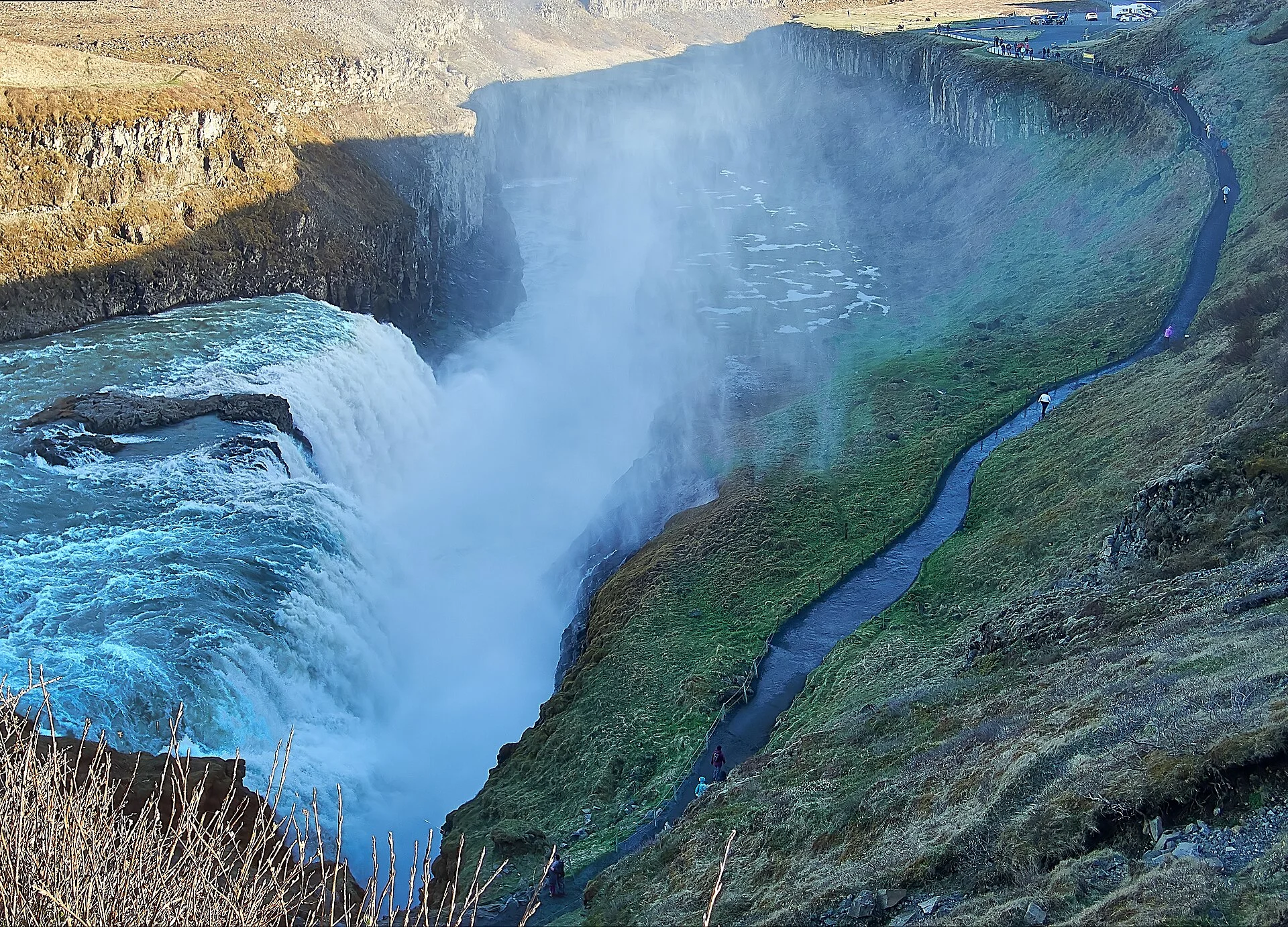
Gullfoss Waterfall Lookout: Choose a Viewing Route
Compare Gullfoss viewing areas, stairs and the route toward the falls. Check closures and surfaces before choosing how far to walk.
Choose a viewing route
The upper view, connecting steps, lower path and Brattholt walk are separate route decisions. Choose by current access and the full return, not only closeness to the water.
Complete route choices
Route: Upper viewing area
- Task
- A broad view with services by the upper parking area
- Limit
- Check the current marked approach
Route: Connection between areas
- Task
- A route between different viewing tasks
- Limit
- Steps and temporary closures need a separate check
Route: Lower path toward the falls
- Task
- A closer angle when available
- Limit
- Open upper views do not prove lower access
Route: Brattholt trail
- Task
- A separate marked walk
- Limit
- Do not use a quick-viewpoint time estimate
Official reserve pages and historical closure notices · · © thingvellirnationalpark.com.
The best Gullfoss waterfall lookout is the open marked view that fits your walking needs that day. The upper and lower areas do different jobs. The connection between them, and the path toward the falls, need their own checks. A wide view can be enough; going closer is an option rather than a rule.
Choose a broad viewpoint first, then decide whether an open lower approach adds a view you want. Check steps and the return. Check the surface too before you commit. Weather can close one part of the route while other views remain available. Follow current barriers rather than a photo from another season. If you need to avoid steps or uneven ground, ask about the exact approach you intend to use.
Last fact checked: 14 October 2026. Route descriptions are orientation, not a live report that every path is open.
Gullfoss waterfall lookout choices: upper and lower areas
The upper area gives a broad way to view the waterfall in its canyon setting. The site care agency's visitor services account also places the café and shops beside the upper parking area. That can help a group that wants facilities close to the start or end of the walk.
The lower area provides a different approach toward the falls. A closer view can make the river's drop more immediate, but it comes with a different walking task. Check the path that is open, not just the apparent distance between a map pin and the water.
The stairs between viewing areas are another part of the route. An upper view being open does not prove that the stairs are available. Nor does a car parked below mean the path toward the falls is clear. Read the current signs for each part rather than treating the whole site as one undivided walk.
For the broader visit, read the Gullfoss overview. The parking guide separates parking terms from free sightseeing admission. This page focuses on the view and the walking route after arrival.
A route comparison in plain English
The comparison below describes tasks, not measured distances. Use the agency's area account and local map alongside it. Check current conditions and any closed section before starting.
- Upper marked view: useful for placing the drops and canyon together. It can serve a shorter visit without adding every closer path.
- Connection between areas: links the visit but includes a separate effort. Check steps and whether the connection is open before planning a circuit.
- Lower approach toward the falls: gives a different angle when available. The route is subject to its own barriers and weather limits.
- Longer route toward Brattholt: is a separate marked walk. It should not be counted as part of a short viewpoint stop.
Do not rank them only by how close they get to the water. A broad view may show the two drops more clearly together. A closer angle may hide part of the wider setting while giving more spray. Decide what you want to see, then match that to a route you can complete comfortably.
Keep the return in the comparison. A path that goes down still asks you to go back up, unless a checked transport terms says otherwise. Do not count only the descent when judging effort. The same applies to time: the last photo point is not the end of the stop.
Understand the view before chasing another angle
Gullfoss has two drops on the river Hvítá before the water continues through the canyon. The official geology account explains the layers of rock and sediment around them. A wider view can help you read that sequence from the river above to the canyon below.
From another angle, one drop can hide part of the next. That is a perspective change, not a different waterfall. Do not assume you have missed the place because a photo taken elsewhere shows both drops in a different terms. Read the river's direction and use the local viewpoint signs.
The source also explains that erosion affects different layers at different rates. You can see the broad form without identifying each layer yourself. A safe view from the marked route is enough for a normal visit. Climbing nearer to a rock exposure is not needed to make the explanation real.
Parking-to-viewpoint directions: choose an actual starting point
Use the signs from the lot you have chosen. The upper parking area and a lower approach are different starting points, even if an app labels both with the waterfall's name. Check which side of the route you are on before following a direction meant for the other area.
The agency names services beside the upper parking area. If those services matter to your group, plan their use before or after the walk. Do not assume a lower starting point gives direct access to every café or toilet without steps or another connection.
For a coach, use the company's arrival and return rules. The driver's meeting point is more precise than a broad map pin. A group can walk away from one place and meet transport at another only if that plan is checked. Do not infer it from a one-way line drawn on an itinerary map.
For a self-drive visit, note the lot and the route back before you leave the vehicle. If you change the viewing plan, check how it affects the return. Do not use an old photo of cars as evidence that the same area is available for your vehicle today.
Surfaces, steps and spray
The route's surface matters as much as its length. Check for steps, wet boards, gravel or a slope on the approach you intend to use. A general description that says a viewpoint is nearby does not tell you whether it suits your footwear or mobility needs.
Spray can wet the ground and affect what you see. Wind may move it across the path or viewpoint. If the surface or view is uncomfortable, choose another allowed position or shorten the route. Do not step beyond a boundary merely to find drier ground or a cleaner frame.
In cold weather, wet ground and spray need more caution. Use the condition report and local signs, then assess the actual route you face. A clear car park does not prove that steps farther along are free of ice. Snow can also hide edges or changes in the surface.
The return may feel harder than the outward walk. Leave time and energy for it, especially after standing still in wind or cold. Keep the group's slower walker in mind when choosing how far to go. The best route is one that works for the whole task, rather than only the first descent.
Accessibility: ask about the route, not just the attraction
If you need to avoid stairs, ask about the exact starting point and viewing area. “Is Gullfoss accessible?” is too broad to describe every route. State whether you use a wheelchair or pushchair, or need a walking aid and which part of the visit matters to you.
A management description or planned improvement does not prove every present-day condition. The agency's documents explain how the site is arranged and managed, but access can be affected by weather or a temporary closure. Check the current approach with the named source before travelling if it is essential.
Do not assume a lower lot is a free shortcut. Read the signs for vehicle access and reserved spaces. Respect the stated purpose of each parking area. The parking guide explains why a general map label cannot supply today's vehicle rules.
Once parked, keep the route clear for others who need space. Avoid leaving bags on a boardwalk or stopping a group across a viewpoint entrance. A shorter marked view can still provide a worthwhile stop without requiring the whole group to tackle each connection.
Weather closures and barriers
Read a closure for the part it names. A lower path may be closed while other viewing areas remain usable. The reverse assumption is also unsafe: an open upper view does not remove a barrier farther down. Follow the local notice rather than using the general attraction status for every route.
The agency has published notices about temporary snow-related closure of the stairs between the areas. One notice from February 2022 documents that type of problem. It is historical evidence of a route limit, not a claim that the same closure is active now.
Visit South Iceland's Gullfoss page points to SafeTravel for conditions. Check that source close to the visit, along with the weather forecast and road details. Each answers a different part of the task.
At the site, respect a barrier even if a view looks close or someone has crossed it. You cannot tell every hazard from the path. A restriction may concern ice, spray, falling material or the protection of the ground. It is not a suggestion to find an alternative way around it.
Plan a realistic stop length
Work back from your next fixed commitment. A coach return time, booked activity or hotel arrival has a clear deadline. A general visitor estimate for Gullfoss is flexible. Choose a viewpoint route that leaves room to get back rather than rely on the shortest time someone else reported.
Allow time for arrival, reading signs and any facilities you need. Waiting for a clear photo can take longer than simply walking to the viewpoint. If the site is busy, moving through the route may be slower too. Keep those parts in the plan without pretending there is one universal duration.
A longer walk does not make the stop more complete by itself. You can choose a broad view and move on if that suits the day. The lower approach or Brattholt trail should add something you want, not become tasks performed because they appear in a guide.
If conditions worsen, shorten the route early. Returning before the next fixed plan is more useful than finishing an optional angle in a rush. A flexible stop has a clear purpose and a clear return, while leaving space to change what you do between them.
A family viewing plan
Choose where the group will stand before cameras come out. Keep children with an adult on the marked route, and explain the boundary in simple terms. A quiet-looking part of the river or a low barrier should not become a reason to test how close you can get.
Give the group an easy return point. If one person wants more photos while others need a warmer or shorter stop, decide how that works before separating. Keep any agreed meeting place specific. A broad “back at Gullfoss” rule does not name one parking or viewing area.
Keep facilities separate from the walking route. A café's hours and a path's access are not the same thing. Plan food, warmth and toilet needs from the private business's current details. A public outdoor-space description cannot provide the opening schedule of the building beside it.
Photographs from allowed ground
A wide view can include both drops and the canyon. A closer angle can emphasise one part. Choose the frame from where you are allowed to stand, then accept that weather and light may differ from the image you saw before the trip.
Rainbows are possible effects of light and spray, not a guaranteed feature. Do not make a narrow time window depend on seeing one. The waterfall itself supplies the reason for the stop. A grey-sky view can still show the river and canyon clearly.
Keep equipment within the space you can use without blocking a path. A tripod, phone mount or large bag should not force another visitor toward the edge of a route. If you need a longer recording, leave room for passing and be ready to move when someone needs access.
Use accurate captions when you share the image. Name Gullfoss and the viewing area if you know it. Include the season or date when it matters. Do not say a winter route is open because your older summer photo shows people on it.
The longer route toward Brattholt
The agency's history and visitor account describes a marked walk from Gullfoss toward Brattholt. It gives an approximate three kilometres one way, or six kilometres for a return. These are source figures checked in October 2026, not a promise of your walking time.
Treat that route as a distinct outing. Check its start and return. Check current conditions too before adding it to the stop. It is not simply the path to the nearest lookout with a different name. Use a current map if you want to follow it, rather than navigate from a paragraph alone.
The official description calls it fairly easy. That broad judgement does not account for every person's needs or the day's weather. Ask about any concern you have and allow time for the return. A summer adjective should not become a winter guarantee.
If a tour stop has a fixed return, check whether a longer walk fits at all. Do not leave the main visit on the assumption that transport will wait. The Thingvellir tours comparison helps you choose a trip by what it actually allows at each stop, rather than the number of places in its title.
Protect the ground around the view
The reserve's rules protect the waterfall, canyon and surrounding nature. Staying on marked routes helps keep new informal tracks from damaging plants and loose ground. A busy viewpoint is not a reason to create another path beside it.
Do not move stones, build a cairn or remove material for a souvenir. The site contains natural features and remains of former land use. A small object can belong to a larger record that is not obvious from where you stand. Leave it in place and read the signs.
The same official page requires consent for drone use. A consumer drone may promise an angle you cannot get from the path, but that does not remove the reserve's rule. Check the protected-area consent and aviation rules separately. This guide does not authorise a flight.
Fit the lookout choice into a park-first day
The Thingvellir National Park overview starts with the old assembly grounds and visible faults. Gullfoss adds a different river view. Give each place its own task and enough time, rather than use the same short stop estimate for both.
For Haukadalur, the Strokkur guide explains watching an active spring, while the Geysir area guide covers the wider place. An eruption wait and a waterfall walking route have different limits. Match the day's spare time to those differences.
If staying overnight, check the park-area hotel bases against your next drive. A rural stay can suit a slower day, but meals and arrival still need a check. Do not let an optional extra viewpoint turn a useful overnight plan into a late, rushed journey.
Frequently asked questions
Is the lower lookout always open?
No such promise is made here. The lower approach has its own barriers and weather limits. Other views may remain available when a specific path is closed. Check current notices and local signs for the route you intend to use. An open attraction label or an older photo does not establish free access to every viewpoint.
Can you avoid the stairs between areas?
Ask the named source about the exact starting point and viewing area that fit your needs. Do not assume a general map label provides a step-free route or consent for an exact parking space. Check the present surface and limits too, especially in winter. A shorter broad view may be the better choice for the group.
Is a closer view better for photos?
It depends on the frame you want. A broad view can show both drops and the canyon, while a closer angle may emphasise one part and include more spray. Choose from allowed ground and accept the day's light. No photo is a reason to cross a barrier or create an unmarked route for a different angle.
Is the Brattholt trail part of a quick lookout visit?
Treat it as a separate marked walk. The official account gives route distances, but that does not establish your time or the current conditions. Check its start and return before adding it. A coach stop or a short viewpoint estimate should not be used as the timetable for a longer out-and-back trail.
Verdict on the Gullfoss waterfall lookout
Choose the Gullfoss waterfall lookout by the open route and the return you can manage. Start with a broad view, then add a closer approach only if it suits the day. Check the steps and weather. Keep transport deadlines in view. A shorter allowed stop is enough when it answers what you came to see.
.jpg)