
Geysir Iceland: Geothermal Area Visitor Guide
Find your way around the Geysir geothermal area. Distinguish its famous spring from Strokkur, check the paths and read the official access sources.
Geysir in Iceland can mean the famous spring itself. It can also mean the wider hot-spring area in Haukadalur. That distinction changes what you should expect. Great Geysir has an uneven history of eruptions. Strokkur, a separate spring in the same area, is the one visitors commonly watch for often seen eruptions.
Use the Geysir area as a place to read and view hot springs from marked paths. Find the signs for Great Geysir and Strokkur rather than treating them as one feature. Do not count on Great Geysir erupting during your visit. Check the route and current notices. Add a hill or woodland walk only if the path and conditions suit you. Meals and transport are separate planning tasks.
Last fact checked: 14 October 2026. The linked official pages are the main factual sources. Older tourism accounts conflict on parts of Great Geysir's eruption history, as explained below.
Great Geysir versus Strokkur in the Geysir Iceland area
Great Geysir and Strokkur are different named geysers. The official protected-area page places them among several hot springs and pools in Haukadalur. A general Geysir map pin gets you to the area. It does not name the spring in an eruption photo.
Great Geysir gave the English word “geyser” its name. It is therefore famous even when it is quiet. Strokkur supplies the more often seen view visitors expect from a stop here. Do not judge the older spring's history by whether you see it erupt during one short visit.
The agency's nature and geology account describes Great Geysir's changing activity and Strokkur's quicker filling up. These are different systems. A burst at one does not start a countdown for the other. A quiet pool is still part of an active hot-spring area.
Use our Strokkur viewing guide if the active eruption is your main purpose. This page covers the wider area, its history and the choices around a walk. You can give Great Geysir time as a named place without waiting for an event that is not promised.
Get your bearings at the site
Start with the local map and the marked pedestrian approach. Find the names of the springs before deciding where to wait. A broad label can cover several features. A line of people with cameras may point to Strokkur rather than Great Geysir.
The agency lists other springs including Blesi, Litli Geysir and Konungshver. Their names help you read the area. Do not turn them into a checklist that takes you off the route. Use signs to see which features the open paths serve. A named spring in an official account is not a right to make your own approach to it.
Give yourself a return point too. If you arrive on a coach, use the company's meeting point rather than a general car-park pin. For a self-drive visit, note where the car is before you start. Several photos of the same broad area cannot replace a clear path back to your transport.
What makes this a hot-spring area
Geothermal heat comes from the Earth's interior. Here, heated water reaches the surface through the ground and forms hot springs and related features. The official geology account places the area within Iceland's western volcanic belt. That gives you the broad setting without claiming that a visitor can see the whole underground system.
The hot-spring area is not the whole zone. The heat reaches beyond it. What you see from the path is a surface expression of that system. A small pool does not show its full extent. A patch of steam does not show the heat beneath all the ground nearby.
Mineral deposits are also part of the view. The agency calls the hot-spring deposits geyserite. They are not spare stones for souvenirs. Their pattern helps show how water and minerals reach the surface. Leave them in place to keep that record intact.
The source discusses rhyolite in the area and at the nearby hill. Rhyolite is a type of volcanic rock. You do not need to name each rock on sight to make sense of the visit. The useful distinction is between a named surface feature and the wider system below the ground that feeds it.
Read this setting alongside the Thingvellir geology guide if your day includes both places. Þingvellir's visible faults and Haukadalur's hot springs show different effects of Iceland's geology. An account of one should not be used as proof of the exact underground layout at the other.
Why eruption histories need a source check
The agency states that Great Geysir has been active to varying degrees. Its geology page reports renewed activity after the south Iceland earthquakes in 2000. It gives 2016 as the last known eruption. Those statements describe a history of eruptions, not a current forecast for a visitor.
An older-style account on Visit South Iceland's Geysir page describes dormancy using different dates and a simplified sequence. The sources do not tell the story in the same way. This guide uses the official account for later eruptions. It does not give a permanent “stopped forever” date.
The practical answer remains clear: do not plan a visit around a promised Great Geysir eruption. Watch Strokkur for frequent eruptions. Read Great Geysir as part of the wider site. A historic eruption photo is evidence of that photo's moment, not of the next event.
Keep estimates distinct from observations. A quoted average for Strokkur does not predict Great Geysir. A report from a past earthquake does not establish activity on your date. Ask the official source about any current notice, rather than turn a general history article into a live status page.
Marked paths and hot-water hazards
Use the marked routes and stay behind the boundaries. This applies even when a feature looks calm. Do not test the water with a hand or foot. A quiet surface does not make nearby ground a safe shortcut.
Do not step over a barrier to avoid a crowd. Nor should you follow another visitor onto an unmarked surface. Their action gives you no evidence about permission, ground strength or the position of hot water. The correct approach is the one the site currently marks for visitors.
Keep belongings close when you watch an eruption. A dropped item beyond a boundary is a reason to ask a ranger for help, not climb after it. A phone or camera can be replaced. The route limits should not depend on how much the item cost.
For a family group, agree on where to stand and who stays with a child before filming begins. Hold the group's place behind the barrier without spreading bags across the path. Leave room for visitors to pass, including anyone who needs a slower or wider approach.
Weather affects the walking surface as well as the view. Rain can make a path wet, while ice may affect footing in winter. Check the conditions on arrival and use a shorter route if needed. A pleasant route in a site guide may still be hard for you. Check it against your own needs that day.
Viewing and photos without leaving the route
Choose a position where you can see the named feature from allowed ground. If wind moves steam across your view, wait or use another marked position. Do not move closer to the water merely because the first frame is obscured.
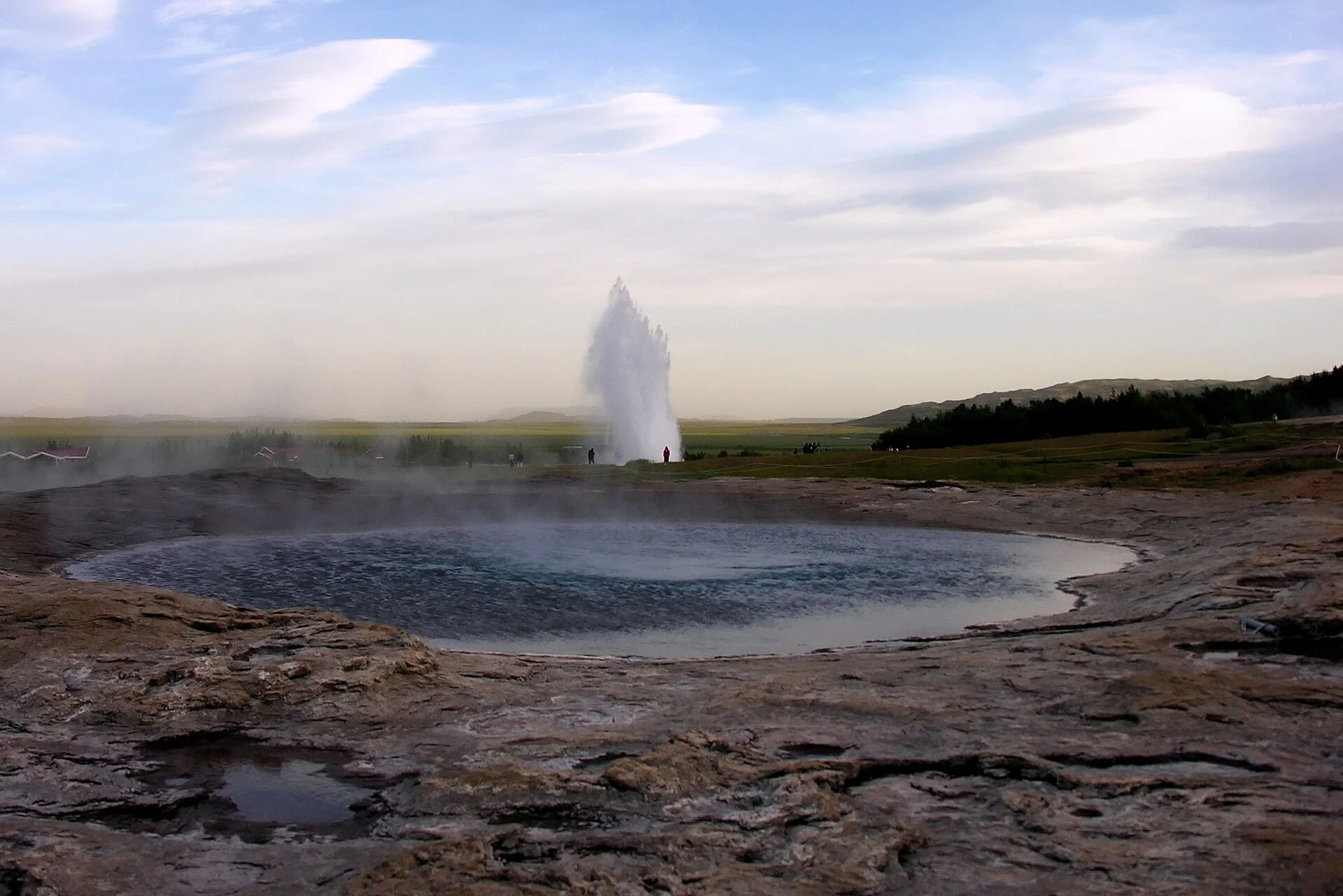
Name the photographed spring accurately. If the image shows Strokkur behind the Great Geysir pool, say so. “Geysir area” is a fair broad caption when the exact feature is not known. Do not use a dramatic eruption image to imply that Great Geysir is currently erupting on a regular schedule.
Older photos have another limit: they may show a different arrangement of paths or barriers. Keep their date in mind when planning. A photo can help you recognise the named place. It does not replace current signs or a site notice.
A longer walk to Laugarfjall
The agency's walking-routes page describes a round trip up Laugarfjall. It names viewpoints over the hot-spring area and toward Helludalur and Bjarnarfell. That gives you a possible second purpose for the stop beyond waiting at Strokkur.
Check whether the route is open and suitable before adding it to the day. The page gives a broad description, not a personal mobility assessment. A hill route asks more of you than viewing from the main path. Allow for the return as well as the climb.
Do not assume the route's signs will use every spelling seen online. The agency's pages use variants of the hill name in different contexts. Follow the local map and current signs for the path, then match them to the described feature. Similar spellings should not tempt you to take an unmarked alternative.
Woodland paths are a different outing
The same official walking page describes routes in Haukadalur's woodland area. It mentions Svartagil and the path toward Gunnarslundur, with a return to the parking area at Hákonarlundur. These are further walking choices, rather than parts of a guaranteed short geyser-viewing circuit.
Choose one route that fits your interests. If you want trees and a longer walk, check its current access and return before setting out. A woodland circuit is optional. You can come for the spring alone, even if the same guide lists more walks.
Use a current map for navigation. The official text describes connections and places, but it is not a turn-by-turn route for every junction. This page deliberately avoids inventing lengths or walking times for those trails. Ask the official source for the details you need.
Keep the geyser area and the woodland approach separate when arranging transport. A car parked for the springs is not automatically at the woodland trail's starting point. Check where each route begins and ends. Return to the location you actually chose, rather than follow a broad Haukadalur pin.
Protected nature beyond the eruption
The protected-area account includes hot springs and deposits, as well as plants in the site's purpose. The visible jet at Strokkur is only one part of that. Small plants around warm ground and the mineral surfaces deserve the same care as the more dramatic feature.
The agency names blue-water speedwell and adder's-tongue among the area's plants of concern. Those names explain why unmarked ground should not be treated as a viewing terrace. Do not pick plants, step through them for a photo or disturb a spring margin to get a close-up.
The area was protected as a natural monument in 2020, according to the official page. That protection is part of the site's current management story. It does not mean visitor access has no limits. Signs and notices still govern the route you can use.
Cultural history in the Geysir area
The agency's culture and history page traces written accounts back to the thirteenth century. The springs have drawn travellers and study for a long time. That history is distinct from the age of the underground system.
The account also describes land ownership. This has changed. It says the state bought the area through an agreement in 2016, before the later protection declaration. Those dates help explain management. They do not establish today's ticket or parking plans, which need their own current source.
The “king's stones” are another cultural feature mentioned in the account. They relate to visits by Danish kings. View them through the site's signs rather than assume any large rock beside a spring has that identity. A named historical feature needs the same careful location check as a named geyser.
Keep the culture of visiting separate from something to repeat. Older accounts describe attempts to stimulate eruptions and interference with springs. That is historical context, not advice. Modern viewing means leaving the water and ground undisturbed while using the routes set out for visitors.
Services outside the protected ground
The official service page names two hotels: Hotel Geysir and Hotel Litli Geysir. It also lists shops and restaurants at Geysir Center. These are just outside the protected area. Plan a meal as a separate task from the spring walk.
Check the exact business and your date before relying on a meal. A list of nearby restaurants is not a live opening schedule. For a late stop or a dietary need, ask the business directly. Do not assume the hot-spring route and the shop share the same hours.
The service page also names a campsite associated with Hotel Geysir. That is not evidence of general permission to camp beside any spring or car park. Read the current campsite plans from the operator if you want that kind of stay. Keep a sightseeing visit and an overnight booking distinct.
This guide does not quote an entry charge or parking fee without a checked current payment source. Read local payment signs and the official details. A “free” label in an older article can describe the attraction while leaving other services unanswered. Do not ignore a current instruction on that basis.
Seasonal access and the drive
The agency's general service page says the area is patrolled year-round. That statement does not promise every path or private service is open at every time. Check the current notice and the conditions that affect your chosen route.
Use Iceland's official weather details and road conditions before travelling. These are separate checks: a road may be open while walking conditions are poor. Keep enough daylight and spare time to return to your base comfortably.
Do not infer winter access from a summer photo. Snow may hide ground edges, and ice can affect the marked path. Keep to the route you can actually use that day. Shorten the stop rather than try to reproduce an older image from a difficult position.
If travelling on a guided day, ask how weather affects the itinerary and return. A supplier's general description does not show what will happen on your date. Read the cancellation and route-change terms. Make plans that fit the booked trip. You need not fit every possible stop into it.
Combine Geysir with the park route
The Geysir area and Þingvellir answer different interests. Use the park for the old assembly and visible faults. Use Haukadalur for hot springs and the Strokkur view. Giving each stop a clear purpose is more useful than carrying the same explanation across both places.
Start with the Thingvellir National Park overview if the park is the main part of your day. The tour comparison then separates ranger interpretation from wider paid trips. Check the actual time at each stop before choosing transport.
An overnight stay gives you more time. You need not fit every place into one day. Compare park-area hotel bases by their location and your next route. A hotel near one attraction does not imply a walking connection to another. Confirm both drives before comparing rooms.
Frequently asked questions
Will Great Geysir erupt when you visit?
There is no such promise. The official account describes an uneven history of eruptions, while Strokkur is the more often seen erupting feature visitors watch. Plan Great Geysir as a named stop for history and geology. Use the local signs to distinguish the springs, and do not treat an older eruption photo as a live forecast.
Does a Geysir map pin mean Strokkur?
It may refer to the wider area rather than a single spring. Check the exact names on the local map and signs. Great Geysir and Strokkur are separate features, with different activity histories. A general pin helps with arrival. It does not name the spring in a photo.
Can you combine the hill and woodland walks?
Only after checking the route, conditions and the time you have. They are additional walking choices beyond a short geyser view. Use the current official map and return points, rather than connect places from text alone. This guide does not supply invented distances or times that could make a longer outing appear easier than it is.
Are nearby shops part of the protected area?
The agency places the named hotels and Geysir Center services outside the protected hot-spring ground. Their hours and plans are separate from the visitor route. Check the exact business if you need food or an overnight stay. A general attraction description does not establish that every nearby service is open on your date.
Verdict on Geysir Iceland
Read Geysir Iceland as a wider geothermal visit with two distinct famous springs. Watch Strokkur for the more often seen eruptions, while giving Great Geysir its own history. Use marked routes and add longer walks only after checking their fit. Plan meals separately from the next stop. Check the road conditions as well, so the visit has room to work.
