

Golden Circle Iceland Map: Stops and Route Order
Find the Golden Circle roads and core sights on a geographic map. Place optional stops, exact arrivals and an overnight endpoint before timing the drive.
Golden Circle roads and optional stops
Tap to open the full-size SVG. The line follows OpenStreetMap road geometry. Dark blue markers show the core sights and city start; brown markers identify possible extra stops.
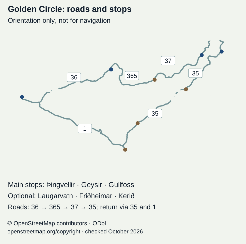
A park-first loop goes from Reykjavík on road 36 to Þingvellir. Roads 365 and 37 connect toward Laugarvatn and Geysir; road 35 reaches Gullfoss. The southern leg on road 35 passes the Friðheimar and Kerið areas toward Selfoss. Road 1 leads back toward Reykjavík. Extra visits need their own time and booking checks. This map is not for navigation.
Stop order with full text
Place: Reykjavík
- Route role
- Possible city start and return
Place: Þingvellir
- Route role
- Core park visit reached on road 36
Place: Laugarvatn
- Route role
- Optional stop between Þingvellir and Geysir via 365 and 37
Place: Geysir
- Route role
- Core geothermal stop on the road 35 leg
Place: Gullfoss
- Route role
- Core waterfall stop northeast of Geysir
Place: Friðheimar
- Route role
- Optional farm stop on the southern road 35 leg; check its own booking terms
Place: Kerið
- Route role
- Optional crater stop farther south on road 35
Place: Selfoss
- Route role
- Southern connection to road 1 for the city return
OpenStreetMap contributors: road geometry and locations · · © OpenStreetMap contributors. Map data under ODbL 1.0; map artwork by thingvellirnationalpark.com.
.jpg)
A Golden Circle Iceland map is most useful when it separates the three main sights from extra stops. Þingvellir, Geysir and Gullfoss form the core visit. Your bed, booked activity and return point decide how to connect them. Use the geographic map below for the route and optional stops, then check official road reports before driving.
Start with the three core places and decide which deserves the most walking time. Add the exact parking or activity meeting point before opening navigation. Optional stops belong on a second list until you know the whole day fits. This page helps choose the stop order. Use official road reports for access and a separate itinerary for time.
Last checked: 15 October 2026. Core places come from Visit Iceland's route description. The official South Iceland local map supplies the wider location reference. It is a stated local map, not a live closure report.
Read the Golden Circle Iceland map before adding stops
The map follows OpenStreetMap road geometry between the city and the named sights. It shows a loop through roads 36, 365, 37 and 35, with a southern return via road 1. Laugarvatn, Friðheimar and Kerið are choices along the way, not required stops. The place list beneath the map gives the same route in text.
One park-first order begins in Reykjavík, then Þingvellir. Geysir and Gullfoss follow. Choose the return for your next destination. Reverse it if an eastern overnight base or an agreed activity makes that more sensible. The map does not require one direction.
The route can be reversed, and each optional stop still needs time of its own.
The local map includes more places than the three core stops. That is useful for choosing a meal or an overnight base. It does not mean every symbol fits into a single day. Read the Golden Circle overview before turning the map into a collection list.
Open the current road layer separately
Use Umferðin for road conditions. Look at the roads between the named stops, not only the destination markers. The last road into a rural hotel or activity can matter as much as the main local route.
Check when the report was updated and read its legend. A coloured line has a defined meaning; do not guess from the colour alone. If a route is closed, a navigation app's alternative needs its own check. A shorter-looking line can be less suitable in the current conditions.
Open the full-size Golden Circle map.
Find the correct Þingvellir arrival point
The park is an area, not one entrance pin. A broad Þingvellir search can lead to the wrong arrival for your walk. Choose the exact centre or lot. Read the park map and select the arrival by the actual task. Keep the walking return in view.
For the assembly grounds, identify the marked path you want to follow and whether you return uphill. For a visitor exhibition, find the right centre and its service hours. For an activity, follow the booked supplier's instructions rather than a general sightseeing pin.
Silfra check-in is a clear example. The activity meeting area, guest parking and entry to the water are distinct parts of the visit. Use the Silfra meeting-point guide to understand that distinction, then the exact instructions supplied with the booking.
Put the walking endpoint on your plan
A short road connection does not tell you how long a park walk takes. The route may include steps or an uphill return. A shared tour may collect the group somewhere different from its drop-off. Confirm that plan rather than return to the first place by habit.
If different members of the party need different walks, agree where they reunite. A map can show the path without showing everyone's pace. Choose a shorter option that uses an established route; do not create an unofficial shortcut to meet a timetable.
Distinguish the Geysir area from the individual spring
Geysir names both the area in common travel use and the famous spring within it. The active spring many visitors come to watch is Strokkur. A Geysir pin helps you arrive in the area. It does not tell you to stand beside one exact pool.
Follow the marked paths after parking. Read the barriers as access limits rather than obstacles between the pin and the photo. The ground and water are hazardous outside the visitor routes. Leave time to watch from a permitted place instead of trying to time an eruption from the car.
The Strokkur guide explains what you are looking at. The Geysir account separates the named features. Those guides do a different job from turn-by-turn navigation.
Choose the Gullfoss viewing arrival and activity point separately
Gullfoss has different viewing approaches and facilities. A broad waterfall pin does not settle which walk suits you. Read the Gullfoss guide and the viewpoint guide before deciding how far to walk. Current barriers govern the last part of the approach.
If you have booked an activity from Gullfoss, use its check-in instructions. Mountaineers places its meeting point at the upper lot by the restaurant and shops. See its Gullfoss product page, checked October 2026. That is not interchangeable with any pin labelled waterfall.
Allow for parking and finding the representative before the stated check-in. The same applies after sightseeing: a path back to a different lot can add an unwanted problem. Keep a note of the actual parking place instead of relying on the general attraction marker.
Put optional Golden Circle stops on a second layer
Visit Iceland names Kerið and Skálholt among the wider area's sights. Other stops may be meals or activities with a booking time. Add them only after placing the core visits and your overnight endpoint. The map is good at showing proximity, but poor at showing how a meal or activity divides the day.
Write a purpose beside each extra marker. A stop for food needs a current service check; a crater needs its own admission and walking plan. A bath needs a booking and time to change. An extra pin can use time you meant for the park. Give it a clear purpose first.
Separate through-stops from out-and-back detours
Look at how the extra place connects to the roads you already plan to use. Some choices fit the onward route; others require returning over the same section. Do not call the second kind a quick extra until you have checked the full diversion and visit.
Keep a removal order. If the core stops take longer, drop an extra visit before rushing the last walk. A booked extra is harder to remove, so place it carefully before committing. Check its cancellation terms and the effect of road delays.
Choose the overnight endpoint before finalising the loop
Compare Golden Circle hotel bases with the map open. A Geysir-side room, a farm hotel and a Laugarvatn guesthouse lead to different next mornings. Place the exact property, not just its town or a local search result.
Then add where you need to be the following day. A bed that looks central to the sights may be less useful before an airport transfer. Check the hotel's approach advice and the actual road report. A room ticket and a drivable route are separate facts.
If you join a city excursion, the endpoint may already be fixed. Confirm rural collection or drop-off before booking a room on the route. A minibus passing nearby is not evidence of a transfer service. Keep luggage needs attached to that question.
Use the map with a timed itinerary
The self-drive itinerary turns the locations into visit budgets. It separates road time from parking and walking. Use it after choosing the places, not as a reason to add every marker from the local map.
Save the route and essential instructions before leaving reliable reception. Keep the supplier's meeting directions and the hotel's contact details available without a live page. An offline map can help with orientation, but it cannot supply a current closure update. Refresh the official report before driving.
A simple departure checklist
- Core stops: Pick the main visit at each of the three places.
- Arrivals: Save the exact lot or booked meeting point.
- Extras: Keep optional markers separate from confirmed bookings.
- Endpoint: Include the actual room or city return place.
- Roads: Read the latest official condition report and its legend.
- Timing: Add walking and meal time to the driving plan.
Frequently asked questions
Can you use this map for navigation?
Use it for orientation, not turn-by-turn directions. It follows OpenStreetMap road geometry and labels core sights and extra stops, but it has no live closure layer. Read Umferðin before driving. Choose the exact parking or activity meeting point before entering a destination in your navigation app.
Must you begin at Þingvellir?
No. A park-first order may suit a history-led day from Reykjavík, but your starting bed or booked activity can suggest another order. Read the whole loop before deciding. A reverse direction does not guarantee quiet paths, and it does not remove the need to check service hours and current access.
Can one park pin serve sightseeing and a Silfra booking?
Not reliably. A broad park pin may lead to a visitor centre or a lot that does not serve your check-in. Silfra has distinct parking and activity plans. Follow the supplier's exact directions and leave time to find the representative. The park map helps with orientation but does not replace the booked instructions.
Does the regional map show current closures?
Treat it as a stated location reference. Its named places and road network are useful, but current access comes from the responsible road service or site manager. Read the latest reports before leaving and again if conditions alter. A road being drawn on a tourism map does not establish that you can use it today.
Verdict on the Golden Circle Iceland map
Use the Golden Circle Iceland map to choose an order, then make each arrival precise. The three main stops belong on the first layer. Put extra visits on a second list and keep the room or city return visible. Join that plan to current road details and a realistic walking timetable.
Map data: © OpenStreetMap contributors, ODbL 1.0. Road geometry was read through the OpenStreetMap routing service in October 2026. The map supplies geographic context, not a promise that a road is open or a journey takes a set time.