
Thingvellir National Park Map: Lots and Landmarks
Find official Thingvellir maps and choose P1, P2 or P5 by the planned visit. Separate centres, activity check-in, static paths and current access.
Park orientation map: parking and landmarks
Tap the map to open the full-size SVG. Numbered landmark markers match the key beneath the map. Roads are solid; smaller paths are dashed. Check signs and official notices before following a path.
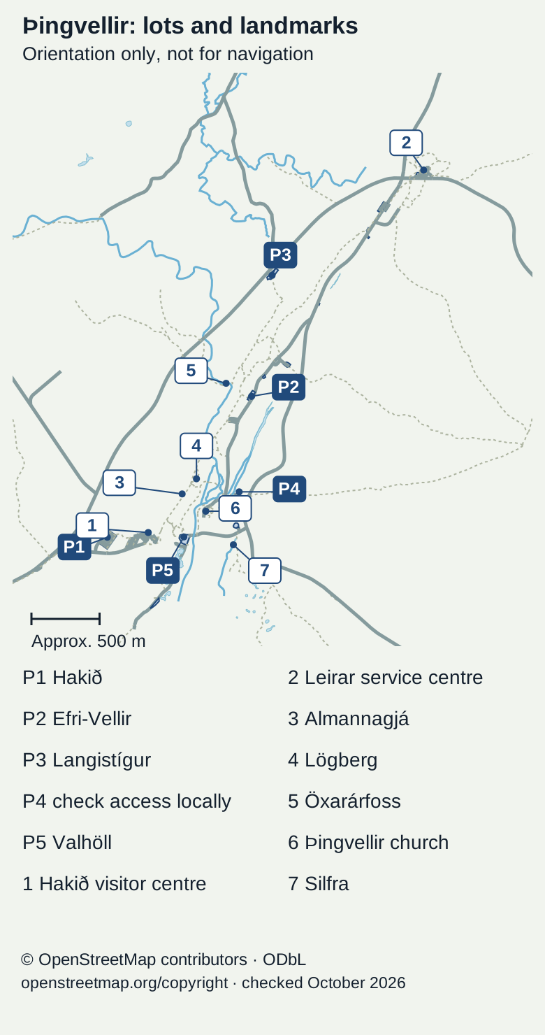
P1 and Hakið are southwest of the main assembly grounds. P2 and Öxarárfoss are farther north. P3 is north of P2. P4 is east of Lögberg; P5 lies southwest of the church. Silfra is southeast of the church, and Leirar is northeast of the main visitor area. The numbered key and the place records provide the same locations in text. This is an orientation map, not for navigation.
Arrival points and nearby sights
Map marker: P1
- Place
- Hakið parking
- Use or limit
- Upper arrival for the visitor centre and Almannagjá
Map marker: P2
- Place
- Efri-Vellir parking
- Use or limit
- Waterfall-side arrival; check the open path
Map marker: P3
- Place
- Langistígur parking
- Use or limit
- A separate northern arrival, not the exhibition centre
Map marker: P4
- Place
- Parking marker east of the assembly grounds
- Use or limit
- Presence on a map does not establish public access; read current signs
Map marker: P5
- Place
- Valhöll parking
- Use or limit
- Lower arrival near the church and Silfra
Map marker: 1
- Place
- Hakið visitor centre
- Use or limit
- Exhibition centre by P1
Map marker: 2
- Place
- Leirar service centre
- Use or limit
- Separate centre northeast of the main assembly area
Map marker: 3
- Place
- Almannagjá
- Use or limit
- Rift cliff and marked visitor path
Map marker: 4
- Place
- Lögberg
- Use or limit
- Assembly landmark
Map marker: 5
- Place
- Öxarárfoss
- Use or limit
- Waterfall on the northern visitor walk
Map marker: 6
- Place
- Þingvellir church
- Use or limit
- Church and nearby assembly grounds
Map marker: 7
- Place
- Silfra
- Use or limit
- Water-activity area; use separate supplier meeting instructions
OpenStreetMap data and park parking reference · · © OpenStreetMap contributors. Map data under ODbL 1.0; map artwork by thingvellirnationalpark.com.
.jpeg)
A Thingvellir National Park map should help you choose the right arrival and walking return. P1, P2 and P5 serve different parts of the main visitor area. Hakið and Leirar are different centres. Start with the visit you want. Use the map below to locate them, then check official notices for access.
Use the official assembly-area map for the main sights and the whole-park map for longer walks. Choose a lot by the first task, not by a general park pin. A static map shows routes and facilities, while current access comes from local notices. Save the return and any booked activity check-in before you leave the vehicle.
Checked: 15 October 2026. The park's hiking page links its assembly-area PDF and whole-park PDF. Its interactive map provides place and facility layers. These are location references, not live route-opening guarantees.
Thingvellir National Park map: choose the scale first
The assembly-area map serves Almannagjá and the old meeting grounds. It also shows the waterfall and church area. The whole-park map is for a wider route choice. Do not assume a short visitor-area diagram covers every trail you might follow beyond it.
The official hiking page identifies former-farm routes outside the assembly area, including Hrauntún and Skógarkot. These need a defined outing and return. Use the walking guide to separate that task from a main-sights visit. A longer line on a map is not simply a spare half-hour after a viewpoint.
Read the legend and orientation
Find the north arrow and scale before interpreting a map's left and right. Read the symbols for parking, toilets and services. A facility symbol tells you what is located there, not that it is open at the intended hour. Keep the current service page beside the map when that detail matters.
Save the map and essential directions before leaving reliable reception. An offline copy can help you follow the chosen route, but it cannot update a closure. Refresh the official notices before the visit and read signs on arrival. A saved version should not outrank a current barrier.
Match P1, P2 and P5 to the visit
The park's parking page places P1 at Hakið by the upper end of Almannagjá and visitor centre. P2 lies east and below Öxarárfoss. P5 at Valhöll is nearest the church and Silfra. The map and labelled place list show those locations.
OpenStreetMap also marks P3 and P4. Their presence here does not extend the park’s published P1, P2 and P5 payment or access guidance.
Choose P1 when the upper view or exhibition is the starting task. Keep the climb back in mind if you walk down into the assembly area. Choose the waterfall-led arrival by the actual open path from P2. For the church area or a booked Silfra visit, establish the correct P5 arrival and onward instructions.
A parking pin is not an activity check-in
The activity supplier's representative may be elsewhere after you leave the guest lot. Read the Silfra meeting-point guide and then the supplier's exact directions. The broad map name Silfra does not tell you when to arrive or where to find your group.
Leave time for payment and the walk from the car. Use the parking reference for the current process. The park map answers where a lot is; the parking page answers how the service is paid. Neither replaces a booking ticket for an activity.
Landmarks need context as well as a marker
Read the park overview to choose which places matter to your visit. Almannagjá explains only part of the rift valley. Lögberg and the booth remains belong to the assembly story. The church is a later building with its own access question. A map joins these places without making their meanings identical.
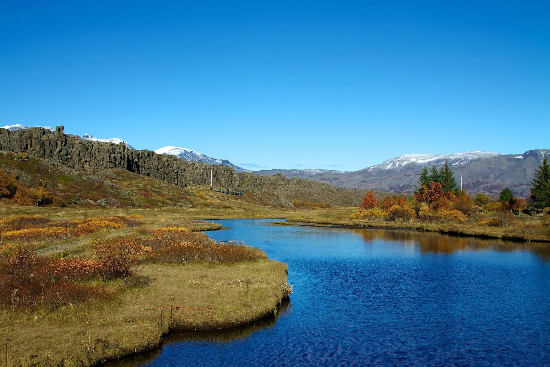
The viewpoint and photo guide uses real credited images to help identify named features. The hero photograph shows part of the park, while the map covers a wider area. Use the actual place account and official map together when recognition matters.
Keep the walking return visible
Choose whether you return to the same lot or meet a vehicle elsewhere. If the party splits, agree a precise place rather than “near the centre.” Hakið and Leirar are different destinations. A name that seems obvious to one walker can send another person to the wrong building.
Do not estimate every route from a straight line. Steps, slopes and river crossings can affect the walk. Allow time for the least confident walker and any rest. A short map distance does not guarantee a quick return.
Static paths and current restrictions
The park's February 2024 closure notice describes damaged walkways and icy paths at that time. It shows why a mapped connection can fail. It does not establish the current state of every route named in the notice.
Read the latest local details for the actual crossing or path. Do not infer that it remains closed forever, or that it reopened because the notice is old. If an essential connection is unclear, ask the park before depending on it. Keep a shorter marked alternative in the plan.
Facilities and services also need a date
Use the visitor-centre guide for Hakið and Leirar. Confirm the service you rely on, especially near closing or a holiday. A toilet or cafe symbol is not a promise of night access.
For an overnight stay, compare nearby hotel bases after the route works. A room within a broad park search area may require a separate approach. Add the exact address rather than let a local label stand in for a real endpoint.
A map checklist before the walk
- Scale: Is this the assembly area or the whole park?
- Start: Have you selected the actual lot or centre?
- Purpose: Which named sights belong to this visit?
- Return: Does everyone know the route or vehicle meeting place?
- Notices: Have you checked current restrictions and local signs?
- Services: Are the needed facilities open for the date and hour?
- Booking: Are activity instructions separate and available?
The tour guide can help if you want an organised route. Check which part of the map the tour actually uses. A local park stop does not include every route shown on the authority's PDF.
Frequently asked questions
Which official map should you use first?
Use the assembly-area map for the main visitor grounds and nearby named sights. Use the whole-park map for a defined longer trail outing. Both are linked by the park's hiking page. Read the legend and current notices before following a route. The broader map does not make every trail part of a short visit.
Does the map tell you whether a path is open today?
Not by itself. It locates routes and facilities, while current access comes from notices and on-site signs. The park's older closure notice demonstrates that connections can be interrupted. Ask about an essential crossing if needed. A line on a saved PDF does not overrule a present barrier or restriction.
Is Leirar the exhibition visitor centre?
No. The exhibition centre is Hakið by P1. Leirar is the service centre by the campsite and road junction. Save the correct name when planning the first arrival or meeting point. A general centre label can otherwise hide a meaningful difference in where you need to be and which service is available.
Can the park pin be used for a Silfra booking?
Use the supplier's precise meeting instructions instead. The national park is an area, and a generic pin can lead to a place that does not serve check-in. Guest parking and the activity meeting area are distinct tasks. Leave time between arriving in the lot and being ready with the booked group.
Verdict on the Thingvellir National Park map
Use the Thingvellir National Park map to choose a precise start and return. Read the assembly-area and whole-park references at the right scale. Keep the current notices beside the static routes, with separate instructions for parking and activities. A map becomes useful when it serves a visit everyone can complete.
The map uses OpenStreetMap data, © OpenStreetMap contributors, under the Open Database License. Place positions and road lines were checked in October 2026. The park’s own map remains the authority for its visitor instructions.